
Reconnecting a Community With a River That Once Brought Disaster
This article originally appeared in Route Fifty.
As Minot, North Dakota continues to recover from 2011’s record-setting flooding, efforts to repair the city’s relationship with the Souris River continue.
When the city of Minot, North Dakota first started rising along the banks of the Souris River in the 1880s with the arrival of the Northern Pacific Railroad, the original settlers probably weren’t thinking too much about flooding. Among North American rivers, the Souris isn’t particularly big and doesn’t seem all that threatening, but don’t underestimate the power of its waters. Sometimes called the Mouse River, it starts in Saskatchewan and dips south across the U.S.-Canadian border into North Dakota before winding through Minot, which is the state’s fourth most-populous city and home to nearly 50,000 residents.
While much of Minot’s downtown area sits safely above the floodplain, neighborhoods of single-family homes and businesses developed in low-lying areas adjacent to the river and a handful of the Souris’ former meandering bends, so-called “dead loops” that were cut off from the main channel. Portions of the river’s route through the city were lined with levees to keep the Souris contained within its banks following major flooding in 1969.
But those flood protection efforts from an earlier generation were, however, no match for a record-setting springtime inundation that lasted many weeks and peaked that June. The Souris overtopped its levees, prompted evacuations, displaced 12,000 residents and damaged or destroyed 4,100 homes in Minot neighborhoods near the river and its dead loops.
That includes the neighborhood of Eastwood Park, where Minot Alderman Shannon Straight grew up. During a visit to Minot in September 2016, Straight gave Route Fifty a tour of the areas impacted by the flooding, including the street near one of the dead loops where he grew up. While the Souris may have been reshaped by civil engineers, the dead loops that remained are ever-present reminders of where the river used to go and the risks that the Souris floodplain poses to neighborhoods that were built on it.
Since the 2011 disaster, which caused hundreds of millions in damages, federal, state and local officials have been busy envisioning how to create a more flood-resilient city, including buying out vulnerable low-lying properties, building stronger levees and allowing the river more room to flood to reduce pressure on the Souris’ main channel during high-water events.
While those physical flood risk mitigation measures are similar to what’s found in many resiliency playbooks, there’s been a parallel volunteer-driven effort underway in recent years to strengthen the community in other ways so it can learn to live alongside a river that will periodically bring high water.
Many in the community, including Straight and Mayor Chuck Barney, have rallied behind Friends of the Souris, a group that promotes the river as an asset for Minot, not something to be feared. That work has been supported by Cities of Service, a non-profit organization funded in part by the Bloomberg Philanthropies that’s designed to assist communities leverage volunteers, foster social resilience and build a stronger and engaged community in the process.
Last year, Friends of the Souris released a survey of the community to gauge attitudes of Minot residents about the river that runs through their city. Only 33 percent of respondents viewed the river in a positive light, as The Minot Voice reported last June.
“The river is a sleeping giant, and dangerous,” one respondent said in survey comments.
Straight, who previously worked as an AmeriCorps VISTA member before returning to his hometown, along with Friends of the Souris envision using the river to enhance parks and recreational opportunities in the Minot area. While that includes more traditional uses like riverside trails, it also involves activating the dead loops, transforming them from forgotten and neglected water courses that are sometimes used for illegal dumping, into assets valued by the community.
Despite the local community’s unease with the Souris, the survey indicated that a majority of the respondents would enjoy greater access to the river, including canoeing and kayaking.
Previous Friends of the Souris volunteer events focused on the dead loops have removed tons of trash and debris from the waterways and adjacent banks.
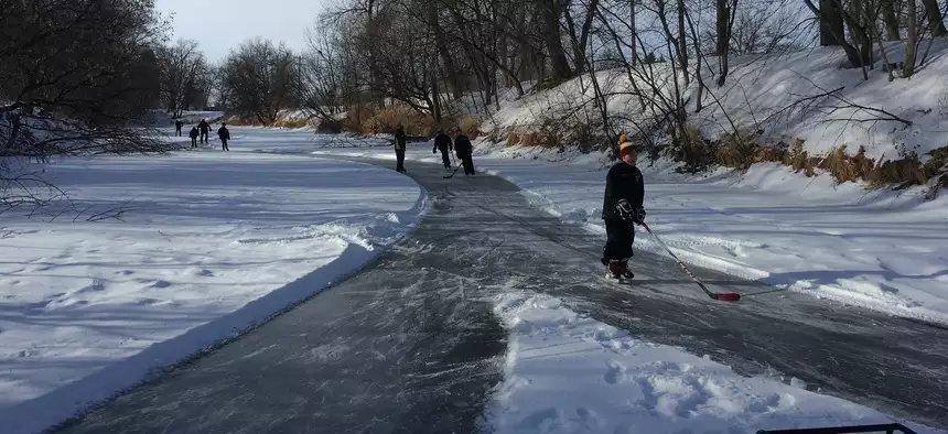
This winter, Friends of the Souris worked with various community stakeholders to create an approximately 2-mile-long ice-skating trackusing one of the river’s dead loops, outfitting a small vehicle with plows to create a smooth skating surface.
Ackerman Estvold, a local architectural and civil engineering firm, surveyed the area and helped Friends of Souris install stairways to make the river more accessible. Materials for the stairways were donated by Dakota Fence. The Minot Area Community Foundation and United Community Bank provided financial support for the Feb. 10 Skate the River event with additional assistance from the Minot Park District.
In April of last year, a community Ride the River bike outing along one portion of the Souris was held as an educational outreach opportunity, which local officials and Friends of the Souris used to explain aspects a forthcoming flood protection project. The event was streamed live on Facebook.
“People were asking some really insightful questions,” said Andrianna Betts, an AmeriCorps VISTA volunteer working on resiliency efforts in Minot. The more community members know about the flood mitigation efforts in and around the city, the easier it will be to heal the long-term scars that the 2011 flooding left.
“That initial goal—reconnecting the community to the river—is happening in these meaningful and beautiful ways. It’s exciting from a sustainability standpoint,” according to Karen Dahl, communications director for Cities of Service.